


le rozier, cassagnes

christo12
User
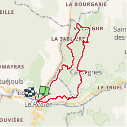

Length
18.3 km

Max alt
925 m

Uphill gradient
1197 m
Km-Effort
34 km

Min alt
406 m

Downhill gradient
1204 m
Boucle
Yes
Creation date :
2018-04-17 13:31:21.923
Updated on :
2018-04-17 13:31:21.923
8h48
Difficulty : Unknown

FREE GPS app for hiking
 SityTrail
IGN / Geographical institutes
SityTrail Plus
The world is yours!
About
Trail Walking of 18.3 km to be discovered at Occitania, Lozère, Le Rozier. This trail is proposed by christo12.
Positioning
Country:
France
Region :
Occitania
Department/Province :
Lozère
Municipality :
Le Rozier
Location:
Unknown
Start:(Dec)
Start:(UTM)
516578 ; 4893260 (31T) N.
Comments